


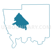
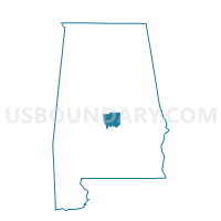
Independence Voting Center, Autauga County, Alabama
About
Outline

Summary
| Unique Area Identifier | 521149 |
| Name | Independence Voting Center |
| County | Autauga County |
| State | Alabama |
| Area (square miles) | 54.97 |
| Land Area (square miles) | 54.90 |
| Water Area (square miles) | 0.07 |
| % of Land Area | 99.88 |
| % of Water Area | 0.12 |
| Latitude of the Internal Point | 32.55196090 |
| Longtitude of the Internal Point | -86.72324850 |
Maps

Graphs
Select a template below for downloading or customizing gragh for Independence Voting Center, Autauga County, Alabama


Neighbors
Neighoring Voting District (by Name) Neighboring Voting District on the Map
- Autaugaville, Autauga County, AL
- Billingsley Government Center, Autauga County, AL
- Booth Volunteer Fire Department, Autauga County, AL
- Jones Community Center, Autauga County, AL
- Mulberry/Statesville, Autauga County, AL
- Old Kingston Vote Site, Autauga County, AL